Need help figuring out where to go in winter? Then let’s have some fun in Northwest Yunnan!
Yunnan. This frontier province, located in the transition from the second to the third step, has the absolute strength to resist the cold air because of the Hengduan Mountains, the Yunnan-Guizhou Plateau, and the mountainous characteristics. At the same time, the winter is as warm as spring.
Generally, people will play in Dali and Lijiang in a point-to-point way in northwest Yunnan. Today, we can play something different, with a longer, more challenging route, string more Yunnan style, and meet more beautiful natural scenery.
So, this northwest Yunnan self-driving itinerary brought today will let you meet the romantic Dali, the quaint Shaxi ancient town, the pure Lanping, the raging Lancang River, the quiet Vixi, the holy Yulong Snow Mountain, the beautiful Lijiang, the clear Lugu Lake and finally the deeply passionate Panzhihua.
First stop: Dali
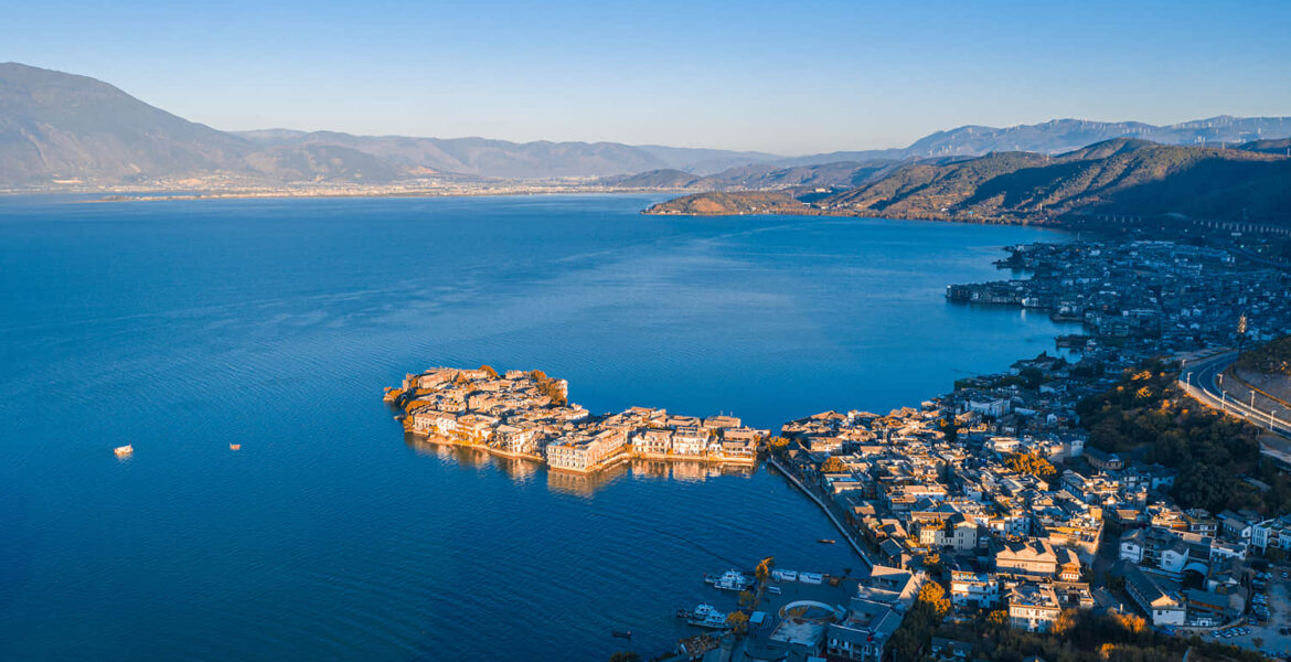
As the transportation hub of western Yunnan, Dali is always crowded with tourists. The beauty of the Cang Mountains and the Erhai and the folklore of the Bai people attract many people who come here specifically for this purpose.
You don’t have to worry about what season to come to Dali. The unique geographical location and topography make it cooler in summer but with more rain.
After winter, Dali has a lower temperature, but it is sunny and suitable for tourists. There are the less hustle and bustle of summer tourists and more tranquility during the winter, which is perfect for leisure.
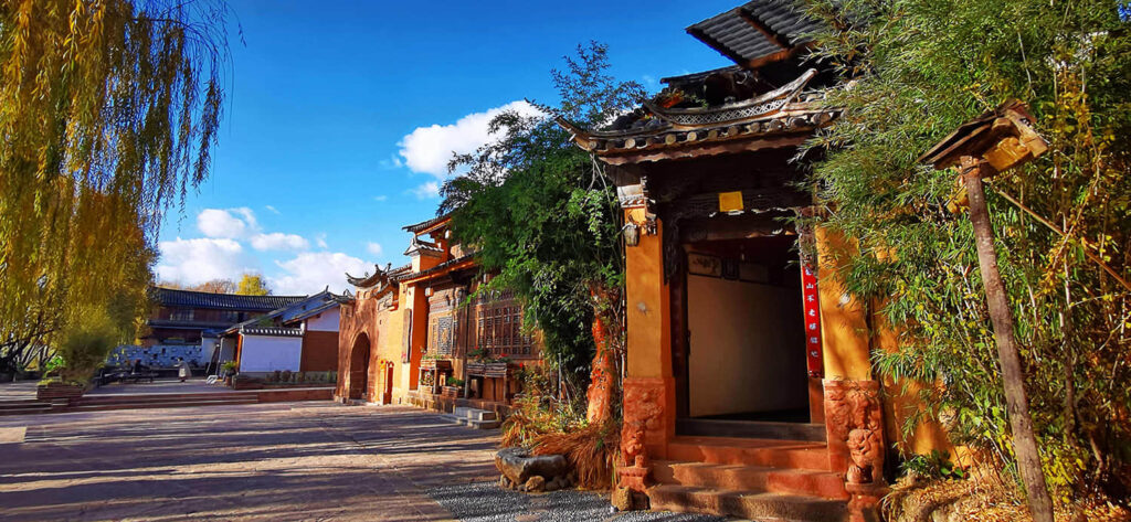
Travelers usually first go to Dali’s ancient city, Xizhou (ancient town), Cang Shan (Cang Mountain), and Erhai. But if you have plenty of time, you should slow down and take a walk in Shimonoseki, the capital city of Dali.
You can walk up here for half a day and not necessarily come across a travel group holding a flag more than in other places in Dali.
The fact is that you can find a lot of people who can only get a little money for the actual project.
It is recommended to visit the Dali Museum first to learn about the history and humanity related to Dali. This information will be helpful for the rest of the trip. The museum covers a relatively large area; it takes at least 1 hour to wander through all the exhibition halls.
From the museum to the southwest and northeast directions, respectively, Longwei Pass and the coastal road.
Longwei Pass is the old town of Shimonoseki and the ancient Tea Horse Road intersection, with more ancient buildings and historical significance.
The Esplanade, on the other hand, as its name suggests, is a scenic highway for driving, cycling, and hiking to enjoy the Erhai Sea. Of course, this place is expected if you want to travel around the Erhai.
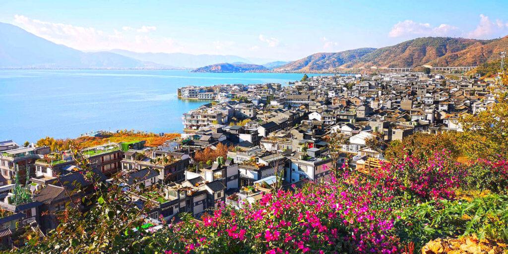
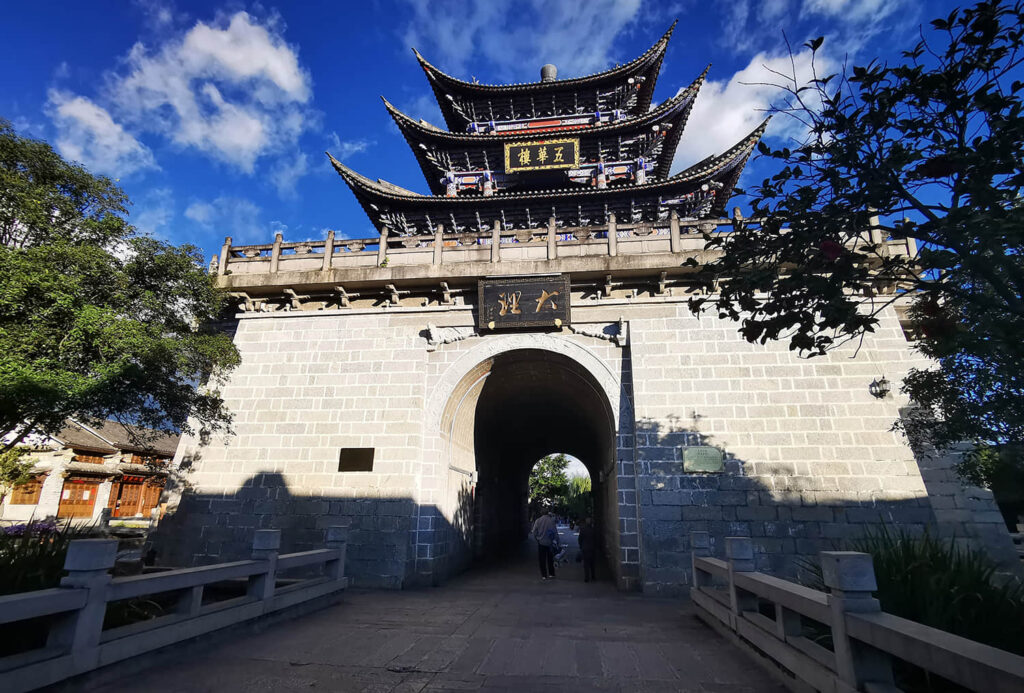
The Dali ancient city and Cang Mountain are located west of the Erhai and northwest of Shimonoseki. As the signature tourist attraction of Dali City, they are considered a must-see when visiting Dali.
The first time you visit ancient city of Dali, you may be influenced by the lively commercial atmosphere and think the old town has lost its ancient charm. Still, if you avoid the vibrant streets and walk in the less crowded streets, you will see a different old city.
Cang Mountain is west of the ancient city; the mountain is north-south trending, composed of 19 peaks, majestic and majestic. After years of development, it is now very convenient to visit the hill, with both the Jade Belt Road for walking and the cable car connecting the mountain.
Driving tips: Dali City, about 257 kilometers from Lamping County, driving time of about 4 hours and 50 minutes; from Dali to the north to take G214, after the er source to bring the er sand line to Shaxi ancient town, and then take S311, G215 to Lamping.
Second stop: Lanping
Snow-capped mountains and ancient towns.
From Dali to the north, Er Yuan is one of the six ancient edicts of Western Yunnan, the Long Daozhao. Travelers to this area come for the Gombe Lake and hot springs.
If you want to soak in the hot springs, you can go to the Dali Geothermal State Resort on the south side of Lake Gombe.
After Eryuan, you will come to Niujie. This may be a small scenery that passes outside your car window. Still, in history, it was a significant town on the ancient tea-horse route. It is rumored that Kublai was soaked in the hot springs of the Flaming Mountain in Niujie during his southern expedition.
In ancient times, horse gangs came to Niujie, and took the trail turns to the northwest direction of the sand creek. Today the path is paved but not high grade with the poor pavement. If you want a better road, you can take the main road to Dienan and then to Shaxi.
Shaxi is a relatively quiet town, but its popularity is rising yearly. When the future crane Jianlan Expressway Shaxi branch is repaired, it will be more lively.
Historically, the ancient town was a salt distribution center on the old tea horse road, providing functions such as a post and bazaar. Now, the only ancient village on the road that has survived still retains its traditional bazaar function.
The most lively place in Shaxi originally was the range centered on Temple Deng Street and Sifang Street. Still, the residents within the range have moved out due to the principle of architectural protection. Suppose you want to experience the lively market of the ancient town. In that case, you can go to the market of Shaxi on Friday or walk to the small villages around the ancient city.
The section from Tongdian to Lanping has been upgraded to a national highway, which will be much better. When driving, you can always see a snowy mountain in front of the car on the left, Xuezhan Mountain, with an altitude of 4295. Lanping, right at the foot of the snowy mountain.
Travelers who come to Lanping usually aim to hike to Luogu Turnip, or continue to the middle row over Bilo Snow Mountain to Fugong.
Luogu Turnip is located west of Yunnan’s Laojun Mountains and is dominated by Danxia, canyon, and meadow scenery.
In Yunnan dialect, turnip usually refers to a valley with thatch or trees, so Luogu Turnip can also be called Luogu Ditch.
For hiking, you usually enter the scenic area gate and hike to the big sheep farm at the top of Laojun Mountain, which usually takes two days. So you need to bring camping equipment and camp in the scenic area.
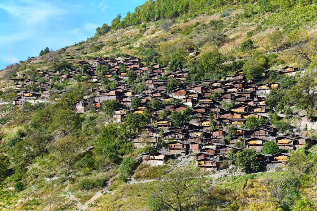
Lanping is a county where the Bai and Pumi people live together. Generally, around the Dragon Boat Festival every year, it is the Pumi people’s “Valentine’s Day.” At that time, the Pumi compatriots will dress up in gorgeous national costumes disguised as a couple and walk around the village.
The county government sometimes organizes a song and dance festival for tens of thousands of people in Luogu turnip, so make sure to take advantage of it.
The path into Shaxi ancient town is very winding and often goes up and down hills, so it is best to leave this section after meals.
The section from Dianan to Lamping has been rebuilt and upgraded, and the road condition has improved in recent years. But in the Yunling Mountains, through the entire length, the elevation fluctuates. The road is located in a river valley and is often wet because of water vapor channel influence.
In addition, this section of the road also often has farm cars, such as tricycles, which will sometimes go irregularly. Plus, the road is usually wet. If the emergency brake, it’s easy to be dangerous. If it’s winter and icy, it’s more complicated. So try to throttle control speed. Avoid emergency brake. In case your tires skid, causing danger.
Driving tips: Lamping County is about 229 kilometers from Vixi County, driving time of about 5 hours and 40 minutes; from Lamping to the west to take S311 and to Yingpan, and then all the way north to take the Yingbai line, through the row, Videng, Baiji flood and to Vixi County. In this section of the line, the road is slightly narrow because of the river, so pay attention to safety when driving.
Third stop: Vixi
After leaving Lanping, you will come to Yingpan, and from here, you will walk along the Lancang River to the Baiji flood.
In this section of the Lancang River, the water speed could be faster and sharper. The landscape is also mainly canyon scenery but less narrow than the Nujiang River canyon, still sandwiched between the Nu Mountain and the cloud ridge.
Baiji flood here, at a glance, maybe just ordinary countryside, but its name has some origins.
Bai means “Bai Zi” and Zi is the people in the Bai language. The two words together mean “the Bai people.” After the elegant Bai, Baiji means the place where the Bai people live.
During the Qing Dynasty, the government set up a flood in Baiji to station soldiers and pass information, so it got the name Baiji flood.
The Lisu people live in Visi, a county located at the end of the three river gorges, influenced by the dry and hot valleys of the Jinsha River. It shows some subtropical influences, such as its relatively strong crop growth. It became the breadbasket of Diqing.
Compared to Shangri-La and Deqin, Vixi is quiet, and most travelers go directly from Lijiang to Shangri-La and Deqin but rarely “take a long way” to Vixi.
Thanks to this, you can see the natural face of the city in northwest Yunnan – Lisu men carrying charcoal, Yi women wearing black hats, Tibetan men buying and selling butter tea, and other people of different nationalities come and go in the city, without too many travelers bothering them, only the ordinary life atmosphere.
Historically, Vixi was an important cultural exchange channel and a place where soldiers had to fight.
To the north, Visi is a Tibetan settlement, and to the south, there are many minority groups living there. The two sides in this channel are conflict and integration; both nurtured a brilliant culture and left many stories and sites.
Self-driving tips: Weixi County is about 202 kilometers away from Lijiang City, and the driving time is about 4 hours and 50 minutes; from Weixi to the east, take G353, passing through the towns of Ludian, Judean, Liming, and Shigu, and then you can come to Lijiang.
Fourth stop: Lijiang
The road from Vixi to Lijiang has been upgraded to a wider national highway with a better road surface than before.
When you get to Judean, go southeast, you will enter the Jinsha River basin and follow it to Shigu.
Shigu is named after a carved monument in white jade, also known as the “First Bay of the Yangtze River.” The river flows southward to this point and is blocked by the cliffs of Shigu Mountain. When it turns to the northeast, it forms a “V” shaped bend of the wonders.
Most travelers who travel to Tibet by car will stop in Lijiang, and some will stay for a few days to get to know this ancient city in depth.
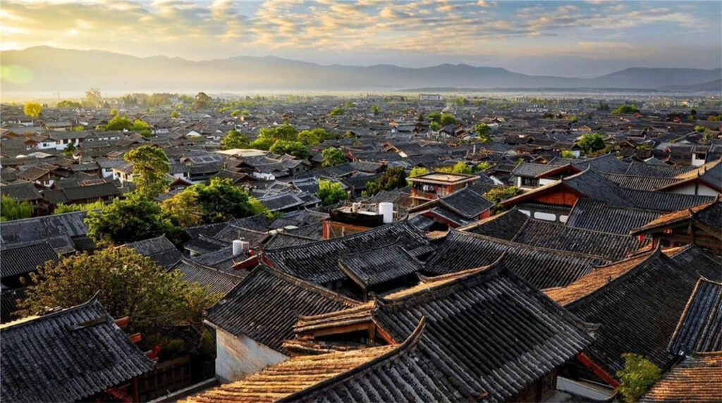
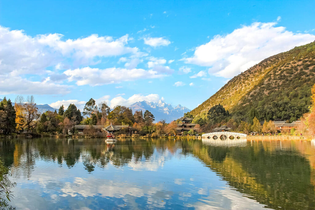
The majestic Jade Dragon Snow Mountain and the flowing Jinsha River are part of the scenery of Lijiang. The old city’s winding paths, with its time-marked tiles and white walls revealing elegance, make people feel like they are talking to time with every step they take.
The ancient city of Lijiang, also known as the old town of Dayan, is only 1.5 kilometers long and wide. Although the inside and outside are various stores, B&B commercial atmosphere is relatively strong, but keeps its appearance from fooling you.
Take a walk down those alleys, avoid the hordes of tourists, find a cafe or inn with a courtyard or a sunny spot, and chat with the owner about Lijiang gossip.
Lijiang to Lugu Lake there are many routes, of which the bus, shuttle bus take the most, is first to Ninglang, and then to Lugu Lake, this section of the road is basically a good road.
But why did we have to go far away from home and take the trail specifically?
This route aims to get to a viewpoint near Ming Yin, where you can see the complete Jade Dragon Snow Mountain.
There is a stone city in Baoshan, which is said to have been built during the Yuan Dynasty and is known as the “Prickly Treasure Panwu” in the Naxi language.
The road from Mingin to Yongning is basically between the Yulong Mountain Range and the Mianmian Mountain Range, and the road will often be high and low, passing one mountain after another.
On the road, you will encounter a lot of passes, these passes will often have parking places, is very good viewpoints.
Plus, the Jinsha River and the Shuiluo River are both here, forming a big channel of water vapor. Whenever the water vapor rises, it will cloud up and form a sea of clouds.
Why stop and enjoy the view if you meet your beloved scenery? Park your vehicle, pull back the canopy, set up a small table, and enjoy the scenery leisurely before continuing.
Driving tips: Lijiang City is about 266 kilometers from Lugu Lake, driving time of about 7 hours and 40 minutes; from Lijiang north to take S223 to Ming Yin, then take the country road to Lugu Lake, the road is more hilly, small roads, remember to horn in case of bends, pay more attention to safety when driving.
Fifth stop: Lugu Lake
As you leap up the winding mountain road to a plateau about 3,000 meters above sea level, you can see Lugu Lake.

This lake is a division point between Yunnan and Sichuan in terms of administrative division, with one-third of the lake going to Yunnan and two-thirds to Sichuan. Still, for a long time, Yunnan was ahead of the development of Lugu Lake, while Sichuan was a step behind.
Now Sichuan has taken the lead, with boat terminals, Mosuo inns, lakeside bars, and star-rated hotels, while the Sichuan side of the lake has a more winding shoreline and a richer natural landscape.
The crystal-clear water of the lake reflects the blue sky and white clouds. The shore of the lake is a group of mountains that change color with the seasons, and among them is Mount Gem, located in north of Lugu Lake.
In Mosuo legend, it is the guardian god of this place, a beautiful and affectionate goddess, and the villages around Lugu Lake are fertile and rich because of her shelter.
At an altitude of 3,770 meters, this mountain is an excellent place to overlook the panoramic view of Lugu Lake. You can see the beautiful picture of a unique piggy bank boat moving in the lake above the blue lake water.
If you are interested, there are some small attractions that you can visit in Lugu Lake, such as the Sea of Grass, the Wedding Bridge, and the Lover’s Beach. Liger Island, Nisai Village, etc.
Driving tips: Lugu Lake is about 289 kilometers from Panzhihua City, and the drive takes 5 hours and 45 minutes. From Lugu Lake, take S307 to the southeast, pass through Ninglang and Battle River, and arrive at Panzhihua.
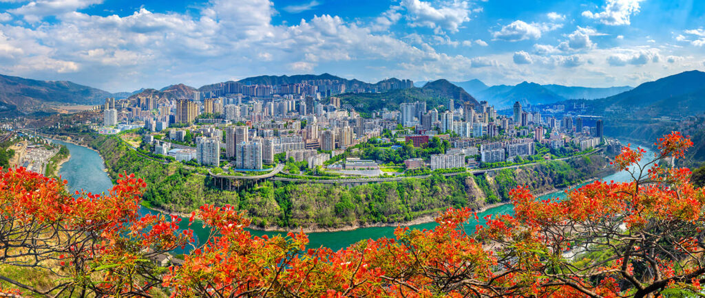
Sixth stop: Panzhihua
The name “Battle River” comes from the Qing Dynasty, when the silver mines of Bainiu Factory were flourishing. To collect taxes and prevent theft, the central authorities in Qing strengthened the armament and taxation agencies in this area. They set up stations to patrol the area. It was thus named “Station River.”
From here, you can gradually notice the natural scenery along the way. Tropical plants gradually increase because you are slowly entering the dry and hot wind area of the Jinsha River.
Before entering Panzhihua, you pass through Huaping, which borders Panzhihua. Crossing here means you officially enter the border of Sichuan.
Huaping is a mushroom-producing county, one of the leading producers of Chanterelle mushrooms in Yunnan, and is also famous for its mangoes in the same dry and hot valley as Panzhihua.
Panzhihua, a city named after a tree, although located in the dry and hot river valley area, is rich in fruits and vegetables, and Panzhihua’s mangoes are even exported abroad.
Panzhihua is a city brought by the Chengkun Railway; immigrants are the characteristic of this kind of city. Foreigners populate the town, so you don’t have to worry about accents because there are southern and northern accents.
Of course, we recommend you look for more fruits here. Panzhihua has more than three hundred days of frost-free days and plenty of sunshine every year. With the characteristics of a dry river valley, the place is ideal for growing fruits, making it fragrant with flowers and fruits all year round.
In addition to the fruit’s excellent taste and sweetness, it also has an advantage of origin, so even travelers passing through the city will stop to bring a few fruit boxes in their trunks.
From Panzhihua to the north, Mii, originally part of Xichang and later subsumed into Panzhihua, seems pleasant compared to the rolling heat of the city.
Because the city of Mii is located with plenty of water vapor and lush forests at the Anning River and the Yalong River confluence, it is much cooler in summer than in Panzhihua.
Walk once in northwest Yunnan, and you’ll be met with the snowy mountains and the folklore. Then cross the provincial border into Sichuan, in Panzhihua, where you can eat fruit and enjoy the local culture!